
Saildrone: Enriching Life through Science
The Saildrone Explorer unmanned surface vehicle (Image by Jenn Virskus, Creative Commons Attribution 4.0 International license, via Wikimedia Commons)
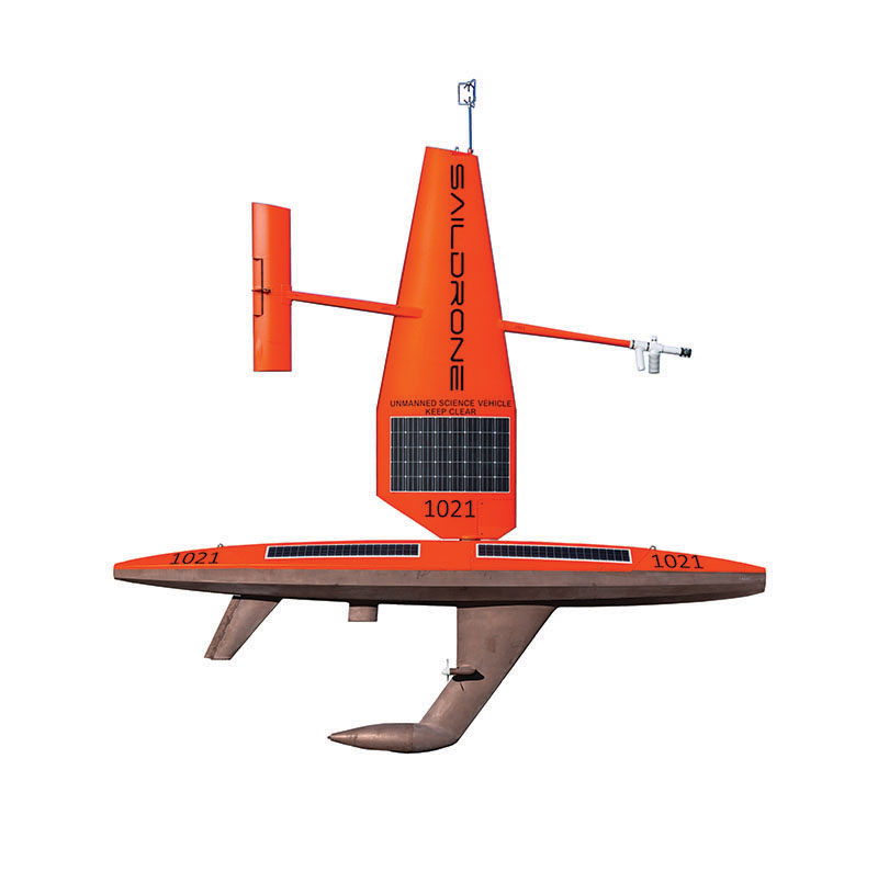
What is a saildrone? you might ask. It’s an uncrewed, environmentally friendly, wind- and solar-powered sailing drone capable of 12-month ocean data collection missions. According to one of its makers, “Saildrone’s measurements and observations, from above and below the ocean surface, provide intelligence and insight for challenges from maritime defense and seafloor mapping to earth system processes such as weather forecasting, carbon cycling, and sustainable fisheries management.”
Why are these unmanned vehicles important? Saildrones can measure meteorological and oceanographic details in real time – providing information on how ocean currents affect hurricanes, how a change in sea surface temperature affects weather on land, and how the shape of the ocean floor affects the distribution of heat around the planet.
This knowledge helps protect people’s lives and property by increasing the awareness of storm paths and intensity predictions.
According to National Geographic, ocean plants (phytoplankton, kelp, seagrass, and sargassum) provide 50%-85% of the oxygen in the atmosphere (the rainforests provide about 30%). Oceans absorb 90% of the heat trapped by greenhouse gas emissions and around a third of the carbon dioxide emitted from human activities, delaying the full impact of global warming.
Saildrones assist the US resource agency National Oceanic and Atmospheric Administration (NOAA), an organization that helps shape the world’s oceans, fisheries, climate, space, and weather policies. According to the agency, its assets include “research programs, vessels, satellites, science centers, laboratories, and a vast pool of distinguished scientists and experts.” To foster its mission to “better understand our natural world and help protect its precious resources,” NOAA uses saildrones to gather data on how our oceans influence climate, and how the vast diversity of underwater ecosystems sustain life on Earth.
So what do the impressive assets of the saildrone do? Equipped with Global Position Systems (better known as “GPS”), a computer, and sensors, autonomous saildrones navigate prescribed waypoints (unique addresses for any points in the world) under the supervision of operators at the Saildrone Mission Control in California.
Sensors mounted on saildrones to study tropical storms and hurricanes (Photo credit: Saildrone, Inc. website)
NOAA-Saildrone missions have surveyed Alaskan coastal waters, the Equatorial Pacific, the Bering and Chukchi Seas, and the infamous seas of the Antarctic Ocean. Saildrones can now track fish and mammals, and measure dissolved carbon dioxide, salinity, and ocean acidification, while detecting and tracking oil spills, charting underwater ocean floor depths for safe navigation, and surveying Arctic ice.
More robust than previous unmanned surface vehicles (USVs), in the winter of 2019 a saildrone completed a 196-day, 22,000-km (13,670-mile) circumnavigation of Antarctica, collecting oceanic and atmospheric carbon dioxide measurements in one of the most hostile stretches of ocean on the planet.
Then on September 30, 2021, a 7-meter (23-foot) saildrone defied all odds and made a Guinness World Record by entering Hurricane Sam in the Atlantic while recording a video of it being violently battered by the Category 4 tempest in 203.4-kph (126.4-mph) winds and 12-meter (40-foot) waves. And yet it survived intact.
The company Saildrone, Inc.’s fleet of USVs, in an achievement announced in October 2023 by Seapower magazine, “surpassed an incredible cumulative distance of 1,000,000 nautical miles during more than 32,000 days at sea, deployed on missions around the globe.” The article puts this feat into perspective: that’s “equivalent to circumnavigating the Earth 48 times and almost 89 years at sea by a single vehicle.”
Evolving the saildrone design, capabilities, and team has been an incredible journey. This million-nautical-mile milestone is a huge achievement in a relatively short time frame.”
– Saildrone founder and CEO Richard Jenkins
According to new research by NOAA oceanographers, published in Frontiers in Marine Science, one of the most important benefits of saildrone research is the continuous readings collected by the crafts’ temperature sensors. Timely, accurate upper-ocean observations now directly inform hurricane intensity predictions, when swiftly provided to weather forecast systems. The saildrone fleet currently includes 136 vehicles in three size variants, providing the most advanced and critical information available for environmental and public safety benefits.